How Map Scale Changes the Shape of a Route
Map scale changes how a route appears: learn to compare its bends and broad geometry at different zoom levels without mistaking detail for direction.
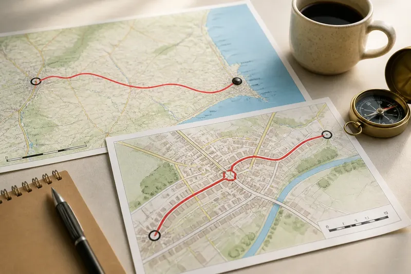
The common map mistake is to judge a route’s shape at just one zoom level. On a small-scale map, bends vanish and a winding way can look almost straight; zoom in too far and every minor kink seems important. Map scale changes the story a route tells, and comparing views helps you separate its broad geometry from local detail.
Map scale changes which bends you can see
A small-scale map covers a broad area in a compact view. It is useful for seeing a route’s general direction and how it connects towns or regions, but it may simplify curves, omit minor roads and compress the space between junctions.
A large-scale map shows a smaller area with more detail. It can reveal sharp turns, short links and the exact shape of a settlement approach, though those details may distract from the route’s overall course.
Scale is not the same as the size of the screen or sheet. A map’s scale relates map distance to ground distance; on a digital map, zooming changes the scale and the amount of detail shown. Check the scale bar or map information rather than assuming two maps display comparable distances.
Compare route geometry at two useful views
Start with a broad view to see the route’s overall direction and its major arcs. Then inspect a closer view at points where the line changes course, meets another route or passes through a town. This keeps the big shape in focus while making the complicated sections legible.
Use the same start and destination in both views. Note where the route stays generally on course, where it makes a pronounced turn, and where a close view reveals a link that the broad view hides. A paper map’s scale bar can help you estimate distances; on a phone, check the displayed route and zoom in around uncertain sections.
Imagine you are reviewing a route from a village to a coastal town. The broad map makes the road look like one clean sweep, while the closer view shows it turning through the village centre before joining the main road. The result is a better description of the route: its overall direction is simple, but the departure requires careful attention at the town junction.
Which parts of a route deserve a closer look?
- Check the first junction: If the route leaves the starting area through several close turns, zoom in and identify the correct exit; if it follows one clear road, keep the broad view for now.
- Check pronounced bends: If a curve changes the route’s general direction, compare its shape at both scales; if the apparent kink disappears on the closer view, treat it as a broad-map simplification.
- Check connections between roads: If a line seems to jump between routes, inspect the junction at larger scale; if no connecting link appears, do not assume the routes meet.
- Check the town approach: If the route crosses a built-up area, zoom in to distinguish through-roads from local streets; if it bypasses the centre, follow the bypass rather than inferring an entrance.
- Check the final approach: If the destination has several entrances or nearby roads, inspect the endpoint closely; if the route stops short, confirm the intended access point on a suitable map.
- Check the map’s detail and date: If minor links are absent or the map may be out of date, consult a more detailed, current source; if the route is clearly represented, use its symbols and legend to interpret it.
It is not worth chasing every tiny waviness in a road at the broad-view stage. Give attention first to turns that change the route’s direction, interrupt its continuity or alter where it meets a destination.
Why can a route look straighter on one map?
A broad map may generalise a road into a smoother line so the whole region remains readable. A closer map can expose bends hidden by that simplification, while a different map projection can alter the apparent shape or direction of features across a wider area.
For route comparison, avoid treating the visual angle of a long line as a precise bearing unless the map is designed and oriented for that purpose. Use the map’s north marker and scale information, and compare like with like where possible.
What should you check at different zoom levels?
Does zooming in change the route itself?
Zooming changes the amount of map detail on screen, not the physical road. The displayed route may nevertheless look different because finer bends and junctions become visible.
Which map scale is best for planning a journey?
A broad view is useful for the route’s overall course, while a closer view helps with junctions, local streets and the final approach. Use both where the shape or connection is unclear.
Why does a road seem to bend differently on another map?
Maps can simplify features differently, and map projections can affect how directions and shapes appear over a broad area. Compare the map’s scale, orientation and purpose before drawing conclusions from its visual line.
Can a phone map show enough route detail?
It can show useful detail when zoomed in, but a small screen may hide nearby alternatives or labels. Check the route at a closer view and use a larger or more detailed map if a junction remains ambiguous.
How do turns reveal the route’s broad geometry?
Read the route as a sequence of larger movements: a long sweep, a change in direction, then a final approach. This description stays useful across different map scales because it focuses on the route’s main form rather than every minor curve.
For example, say you are comparing two mapped roads from a market town to a harbour. At the broad view, one appears to arc inland while the other follows the coast; at the closer view, you see that the coastal option bends through a built-up area and rejoins the inland road near the harbour. Your resulting comparison is specific: the options share part of their approach, but take different courses before they meet.
Use map scale as a way to ask what detail is being hidden or introduced, not as a contest to find the neatest-looking line. A route’s shape becomes easier to interpret when you move between its broad course and the turns that define it.
Before relying on a route for a particular journey, check a current detailed map at the section where its course changes or connects to another road. That is where a line that looks continuous at one scale may need a closer reading.